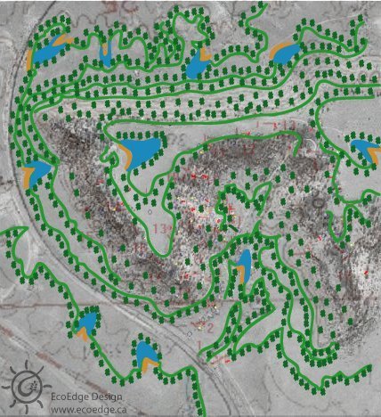
If I'm reading the contours correctly, I'm assuming that the highest point, or ridge-line, is around the upper 1/3rd section of the pic, near the center most dam. That looks like a bare ridge...if, so, and if I were you...I'd slap a whole lot more trees on top of that ridge. It's going to do a lot more for water conservation, inhibit erosion, stabalize the soil, catch particles from the wind to build soil, and help with nutrient dispersal down-hill.
You are reading it correctly. The image is just a model to give an idea of what can be done. There would be more trees planted, but for demonstration purposes the image was simplified.
Thanks for clearing that up. I just wanted to make sure that ridges are not left bare.
It's funny how many people want to clear ridges to build in the spot most exposed to the elements, and don't even consider the ecological consequences.
It's even funnier, that once a ridge is cleared...people don't ever think about the benefits of planting on them again. One benefit of tree planted ridges that I forgot to mention, is the down-wind possibilities of rain making.
Thanks for the demo, by the way...looks groovy. You've inspired me to do a similar thing to a couple downloaded airial (sp?) photographs, just as an excercise.
Yeah, because of scale there was not a lot I could do regarding tree representation. If scale were taken literally, I think one tree on that diagram would be almost 1000 ft high and have a canopy 100 ft in diameter.
I have to say, that this is a WONDERFUL exercise for any person practicing permaculture.
Download a satellite photo of just about anywhere, it doesn't matter where...through eyeballing and guess-work, figure out some rough contours, and start going to town slapping down swales and small dams/ponds, trees etc. in a photo-shop-like program.
If you can get a good shot of an area with well terraced fields on contour (there are quite a few in the Nebraska area, as opposed to the upper/eastern midwest. Nebraskan's and Iowans like to go on contour...(habit from the droughts and floods in the area) further north, and east, it's a little different, I know this for a fact, having flown over the area numerous times)...anyway, if you can find good terraces on contour, you can sometimes get lucky, and even see the key-line. After that, find a good place to put a settlement with access...and then go to work laying down sectors.
I actually got lucky, and with Terra Server, found a rather good resolution satellite photo of my Uncle's place in DuBois, NE. It was taken in late autumn...you can see the shadows, and dark spots where moist soil usually is. You could even kind of tell wind direction from trees! So...there's a LOT of permaculture practice you can do. Just remember, the map is not the territory, and pictures (although worth a thousand words) are still far from reality.
I would recommend that anybody doing a professional design, download a good resolution satellite pic of the property before they go on-site. You can really wow your client, by coming prepared.
Teachers might consider doing this as a class project. Divide the students into groups. Print up a random satellite photo, give them some climate and client data and say...HAVE A BALL! I promise that they will. I've been having a ball doing it all week!
6 comments:
If I'm reading the contours correctly, I'm assuming that the highest point, or ridge-line, is around the upper 1/3rd section of the pic, near the center most dam.
That looks like a bare ridge...if, so, and if I were you...I'd slap a whole lot more trees on top of that ridge. It's going to do a lot more for water conservation, inhibit erosion, stabalize the soil, catch particles from the wind to build soil, and help with nutrient dispersal down-hill.
You are reading it correctly. The image is just a model to give an idea of what can be done. There would be more trees planted, but for demonstration purposes the image was simplified.
Thanks for clearing that up. I just wanted to make sure that ridges are not left bare.
It's funny how many people want to clear ridges to build in the spot most exposed to the elements, and don't even consider the ecological consequences.
It's even funnier, that once a ridge is cleared...people don't ever think about the benefits of planting on them again. One benefit of tree planted ridges that I forgot to mention, is the down-wind possibilities of rain making.
Thanks for the demo, by the way...looks groovy. You've inspired me to do a similar thing to a couple downloaded airial (sp?) photographs, just as an excercise.
Yeah, because of scale there was not a lot I could do regarding tree representation. If scale were taken literally, I think one tree on that diagram would be almost 1000 ft high and have a canopy 100 ft in diameter.
hehehe...so you transplanted some giant redwoods! COOL!
I have to say, that this is a WONDERFUL exercise for any person practicing permaculture.
Download a satellite photo of just about anywhere, it doesn't matter where...through eyeballing and guess-work, figure out some rough contours, and start going to town slapping down swales and small dams/ponds, trees etc. in a photo-shop-like program.
If you can get a good shot of an area with well terraced fields on contour (there are quite a few in the Nebraska area, as opposed to the upper/eastern midwest. Nebraskan's and Iowans like to go on contour...(habit from the droughts and floods in the area) further north, and east, it's a little different, I know this for a fact, having flown over the area numerous times)...anyway, if you can find good terraces on contour, you can sometimes get lucky, and even see the key-line. After that, find a good place to put a settlement with access...and then go to work laying down sectors.
I actually got lucky, and with Terra Server, found a rather good resolution satellite photo of my Uncle's place in DuBois, NE. It was taken in late autumn...you can see the shadows, and dark spots where moist soil usually is. You could even kind of tell wind direction from trees! So...there's a LOT of permaculture practice you can do. Just remember, the map is not the territory, and pictures (although worth a thousand words) are still far from reality.
I would recommend that anybody doing a professional design, download a good resolution satellite pic of the property before they go on-site. You can really wow your client, by coming prepared.
Teachers might consider doing this as a class project. Divide the students into groups. Print up a random satellite photo, give them some climate and client data and say...HAVE A BALL! I promise that they will. I've been having a ball doing it all week!
Post a Comment